Five people in high visibility jackets hold up an old station platform sign saying "Kings Heath"

Update on New Train Stations

On Wednesday 1st October Kings Heath Neighbourhoods Forum hosted a public meeting with a panel of guests involved with the opening of the Camp Hill Line stations to update residents on progress and answer their questions. The slides from the meeting with extensive details and photos are available by clicking the link. The key information of interest to residents is summarised here, comprising information from the slides, the presentations and the Q&A.

Progress towards opening

The stations will be open for passengers in 2026.

At this stage they cannot confidently forecast or commit to an opening date – see below and the slides for further info on why. From various pieces of information given at the meeting it seems likely this will be no earlier than March ‘26, but before July ‘26.

There will be a lot of publicity once the open date is set, and this will be at least 4-6 weeks in advance of the opening.

It’s worth noting this does not represent any further delays to the work, as announcements earlier this year referred to the construction of the stations being completed, or the stations being “finished” by the end of ‘25, which is still on track to happen. Before the stations can be used by passengers there is a lengthy and complex process of testing, training, certification and transfer of ownership of the sites to the rail/train operator – called “Entry into service” works. See below project plan from the slides.

Project timeline from presentation slides

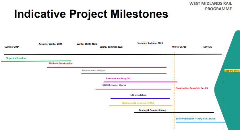
Entry into service works are very complex and normally take several months, although some testing can start before the building works are complete (see above) most of this work has to wait until construction is finished. Adding further complication to these sites the ownership of West Midlands Trains is changing in February ‘26, during this period of hand-over/entry into service. The lack of a firm opening date seems to largely stem from the combination of the complexity of the entry into service works leading to uncertainty in how long they will take to complete, along with the current ownership/management of the stations not (yet) being in the hands of the body that will open them.

Official opening

They intend to have a grand opening ceremony and/or party for the stations, but no details are available for this yet.

Further construction works and disruption

You can find update to date information on each station’s progress at any time from Transport for West Midlands’ dedicated Camp Hill line page. The picture as of the meeting date is:

Kings Heath

Highways work is largely completed now, at some point further minor works will be needed to bring the new pedestrian crossing lights into service, and to do some other finishing works including resurfacing one carriageway.

Pineapple Road

Highways work is ongoing and progressing well, expected to be finished in Mid-November

Moseley Village

Some further utilities and highways permissions are being finalised before work can begin fully, this is expected by mid-October, with roadworks to be completed by Mid-December.

Train service details

Trains will run into and out of New Street.

Trains will continue onto Kings Norton (from Pineapple Road) before “turning around”. Passengers will be able to get on or off at Kings Norton.

There will be 2 trains an hour between 06:00-23:00, Monday-Saturday; 1 train an hour on Sunday starting a little later, and finishing a little earlier.

Fares are “zone 3” meaning they will be roughly the same as Kings Norton to New Street, likely a little cheaper. (This is £3.80 peak fare currently).

Trains are 4 carriage, Class 196 diesels. These have a more “open” design than some other more cramped local train types, with increased standing space, and fewer seats. There is nominal storage for 3 bikes per train, but at the discretion of the conductor (as is transport of more than 3 bikes), so it seems likely this will be difficult, if not impossible to guarantee or depend on during peak times.

Station infrastructure

There will be community workshops in the coming months to help inform the details of design and artworks. They intend to have some mosaics as well as some information/history/heritage boards at each site (see examples on the slides). There is a possibility Kings Heath will have a mural, given the strong links with the High Vis Street Art festival and Enjoy Kings Heath (the KH BID).

Kings Heath and Pineapple Road have storage for 32 bicycles, while Moseley has storage for 50.

Parking

None of the stations will have parking, but will have drop-off areas only. There is a station car park at Kings Norton.

Parking on surrounding streets will be monitored. The panel mentioned Birmingham City Council and the WM Mayor office have made assurances they will provide specific support for parking enforcement around the station, in terms of illegal parking.

There has been a previous parking survey conducted to assess the baseline parking levels around the stations prior to them opening, if there are reported issues with a greater volume of parked cars after station opening there will be a second survey conducted around 6 months after opening to compare to the earlier one and assess where these problems are occurring. If problematic increases are shown in the survey comparison then it will trigger a planning and consultation process for making changes to address these issues.

It’s worth noting any concerns and issues which arise can be best addressed at a local level with the local councillors for Moseley, Brandwood & Kings Heath & Stirchley. As well as, from a more long-term perspective, with the respective Neighbourhood Forums for the wards. Neighbourhood Forums are responsible for developing the local ward plans (alongside councillors), and incorporating aspirational measures to tackle problem parking in specific locations can be a useful tool in advocating for future funding allocations. The opening of the stations will roughly coincide with the next local council elections, which also means a subsequent review and update of the various ward plans with the incoming councillors which could be timely.

The future of the line

The station platforms have been built to accommodate up to 6 carriage trains, so there is a possibility of increased capacity there if there is high demand.

The number of trains per hour is constrained by the capacity of New Street and there is very unlikely to be any increase in the number of trains per hour within the next 10 years or so

Opening up further link lines (the “chords”) to take trains into Moor St instead of New Street, and allow more trains per hour is a theoretically possibility but there are no firm plans on table for this at the moment.

It is unlikely the line would be electrified as there is no likelihood of funding to support this.

There are no plans for a process to “name” the line, but this may happen in the future.

The trees cut down near to the line, (mostly between Kings Heath and Pineapple Road) will not be replanted, as these were removed for operational reasons. There may be some replanting with smaller shrubs in places, but sightline and noise issues for residents will be addressed primarily with a 1.8 m high fence.

Kings Heath & Moseley Places for People Consultation

Many of you will have received a letter from the Council about the latest consultation for the “Places for People” scheme in Kings Heath, also known as the Kings Heath Low Traffic Neighbourhood (LTN).

The consultation and documents showing the various plans can be found at:

https://www.birminghambeheard.org.uk/economy/khmpfpphase2/

The consultation is open until June 9th and we want to encourage people to submit their feedback to help deliver a scheme that works in the best possible way for the local area.

As part of the consultation there have been a number of focus group style meetings held and some of our committee have attended and made notes on a range of questions residents have asked. We’ve reproduced some of these here to help clarify some aspects so that people can submit informed feedback to the consultation. All this information should be treated with the caveat it is only our understanding of the information we have received, and only correct as of the publication date. The details of the plans are under constant review by the council and so things will inevitably change, please check the current information on the above website.

A map showing the Kings Heath and Moseley Places for People plans
Map from consultation website showing the overall plans for the scheme

There are some important points worth clarifying about where we are in the entire process of the Places for People scheme:

  • The consultation is on the specifics of the design of the scheme, not on whether the scheme will go ahead
  • For the East side of the High Street a Traffic Regulation Order (TRO) will follow for the final designs, including changes made from these consultation plans to the final ones. This will involve a statutory consultation phase on the TRO
  • Many of the fine details of the plans (e.g. exact bollard placement, flow of traffic around zones) are not fixed at the moment, and will be decided based on the consultation.

The existing modal filters are “Phase 1”

  • Originally installed as an experimental traffic order during the pandemic
  • Made permanent in 2022 following further consultation phases
  • Existing arrangements of wooden planters and temporary signs will be replaced by fixed concrete bollards in conjunction with expansion works

The expansion is “Phase 2”

  • Consultation was held in 2021 on original plans and received 5000 responses
  • Plans were revised and targeted engagement was done in 2022, e.g. with residents on specific roads
  • Further consultation was held in March 2024
  • Now followed by current consultation

We’ve broken additional information down into the different zones to allow it to be cross referenced to the overall plan/map and the detailed documents on the consultation website.

Howard Road/Vicarage Road (Phase 1)

White on plans. Plans show amendment to current modal filter placement moving them to directly at Howard Road. This is open to change and is ultimately a choice between the current placement of the planters and the proposed location directly at Howard Road. With the former, there is a lot of illegal parking in front of the planters, especially school traffic. With the latter, there is the danger of drivers starting to drive across the pavement and grass to go around barriers. The council believes the problems with the latter can be addressed by additional barriers (e.g. low barriers alongside All Saints/Hazelhurst/Colmore Roads from Howard Road junctions to houses) so this is the favoured solution. If you can contribute further insight to this decision then that will be welcome.

Highbury Road/Grange Rd (Phase 1)

Pink on plans. Currently the filter at the junction of Highbury Road and Grange Road means a long stretch of Highbury Road which is a “cul-de-sac” for cars and goods vehicles. This is causing inconvenience for deliveries etc, and problems for large vehicles needing to reverse some distance. To remove the dead end on Highbury Road a diagonal filter will be placed to direct traffic right onto Grange Road. These filters mean the road is too narrow for two-way traffic so the section of Highbury Road from Silver St has to be one-way, as does Grange Road – effectively the use of a diagonal filter to solve the dead end issue on Highbury Road necessitates a knock-on solution of a one-way loop in this area to take traffic back to Highbury Road via Silver St. There is scope for revisions to the exact placement of filters and one-way streets, so check the latest documents and offer feedback.

Station Road/Westfield Road (Phase 1)

Lime Green on plans. As the other half of the diagonal filter from above this section will also need to have some one-way streets. The exact design of this is subject to change, and we believe there may be some updates/alternatives provided soon, so make sure to offer feedback if you have views.

West side of High St (Phase 1)

Yellow on plans. As with above areas there are some linked designs on account of the diagonal filters. The principle of moving the filters back a little from where they are currently placed in respect of the High St is seen as necessary to remove “cul-de-sac” arrangements that currently exist. However, the exact one-way system design (where needed) is not fixed and subject to the consultation. Existing Silver St filter (by Lidl) will stay the same, but replaced with fixed concrete/metal bollards. Residents have concerns on some of these streets (E.g. Station Road, Grange Road) about parking problems related to High St shopping and the new station. There are calls from residents for a parking permit scheme in this area, which is being explored.

York Road

Persistent vandalism of the existing bollards has led to a slight change which is already in place with new bollards at the top and bottom end and removal of some planters. In the expansion works these will be replaced with a fixed concrete row of bollards at the West end (near Grace and James), and a collapsible “coffin” bollard at the High St end which cannot be removed, and is opened by a key specific to this bollard which businesses will have. Meaning deliveries will only be able to access York Road from the High Street end, and only when let in by a business. There is a hope this can be covered by CCTV in the future. Closure at both ends is seen as necessary to prevent the rampant illegal parking which current blights the road. Residents seem keen for a true pedestrianised zone, however, there is not consensus amongst the businesses on York Rd to any limiting of deliveries, either to particular times, or to certain parts of the road, and so no prospect of a more extensive pedestrianised area, i.e. a zone which is entirely inaccessible to cars.

Valentine Road (Phase 2)

Dark green area on map. The existing Poplar Road Filter will be removed. All the streets in this area will be accessed from the High St side, with traffic returning to the High St. The roundabout at Cambridge Rd will be replaced by a diagonal filter meaning from Valentine Road at this junction cars can only access Poplar Road. Currently it’s proposed Valentine Road is one-way towards Poplar Road. [EDIT: Councillor Knowles from Moseley has let us know the one-way section on Valentine Road would start from Ashfield Road, and Valentine Road between High St and Ashfield would remain two-way]. Kings Heath School have been actively involved in focus group discussions around the details of the plans for this area.

Heathfield Road & South (Phase 2)

Light Grey area on map. All the roads in this area will be accessed from the High St, with traffic returning to the High St. Addison Road will have a “bus gate” (blue symbol on map) which will be enforced with an Automatic Number Plate Recognition (ANPR) Camera which will automatically issue fines for cars driving through it. Residents on Institute Road have been calling for restrictions to prevent speeding and reduce traffic for a number of years. Some roads in this area will be one-way, due in part to use of diagonal filters meaning the roads are too narrow at the junctions for two-way traffic, but also as some of the existing streets are barely wide enough for two-way traffic anyway. In the designs longer sections of road are generally not one-way due to concerns about speeding. Mossfield Road has a modal filter at the junction with Bagnell Road and is one of the few roads in the designs which is a dead end, requiring vehicles to turn around and return down Mossfield Road to the High St.

Barn Lane (Phase 2)

Green on map. This area will be access from Wheelers Lane. Original designs from 2021 were amended with consultation from residents of Barn Lane to have a modal filter on Barn Lane to prevent through traffic and speeding. This means access into the below areas from the South/High St end will be via Wheelers Lane, the Swan Corner roundabout by The Billesley and Brook Lane

Gaddesby Road/Melton Road (Phase 2)

Dark Pink on map. Accessed from Brook Lane/Springfield Road from the East, and Billesley Lane from the North, this will be a small one-way loop returning traffic to Springfield Road. This is the other side of the Addison Road bus gate, and so through traffic in the form of buses will pass through this zone from/to the light grey zone, but cars cannot drive through this area into Addison Road, or from Addison Road into this area without receiving an automatic fine.

Billesley Lane to School Road/Springfield Road (Phase 2)

Light pink on map. This large area will be accessed from Billesley Lane from the North and Springfield Road/Brook Lane from the South. Traffic coming from Springfield Road will only be able to access Cambridge Road or School Road at the existing roundabout. Instead, the diagonal filter that replaces the roundabout will mean that traffic from Springfield Road will only be able to access Cambridge Road or School Road (and vice versa).  Traffic that proceeds along School Road in the direction of Moseley will only be able to travel as far as Greenhill Road before being directed down that road, which will take it back to Billesley Lane. In line with rationale described in Highbury Road area above the existing Cambridge Rd filters are replaced with the diagonal filter at the roundabout to remove need for vehicles to have to turn around/reverse down a long section of Cambridge Road.

School Road/Oxford Road (Phase 2)

Blue on map. This area can only be accessed from Wake Green Road.

St Agnes Road (Phase 2)

Light pink on map. This area can be accessed from Wake Green Road and Billesley Lane.

Billesley Lane (Phase 2)

This will have a 20 mph speed limit and traffic calming measures. A range of options have been considered and a series of “chicanes” are the current plan, which limit traffic to a single lane with signage indicating who has priority. These were the preferred option for the local councillors in Moseley.

General points of clarification

  • With the exception of the section of York Road which is currently pedestrianised the plans do not prevent access to any roads. They only add restrictions on where specific roads can be accessed from. The coloured areas on the map and referred to above are areas which drivers cannot drive through, they will have to return (typically) to the main road they entered the area from.
  • One-way streets will be contraflow for bikes – i.e. bikes can travel in both directions.
  • The fixed bollards will be similar to ones seen across the city to prevent through traffic, such as on Alfred Street/Howard Road. These will just be the physical infrastructure for now, but there is a general openness to improve these in the future, such as adding vegetation/sustainable urban drainage. The challenge is the adoption of such features in terms of responsibility for ongoing maintenance, where resident’s groups could have an important role to play in enabling these.

New bus lane enforcement cameras in Birmingham

Motorists driving in bus lanes on the Lichfield Road, Tyburn Road and Pershore Road after Monday 4 September 2017 will run an increased risk of a fine. That’s the date when new bus lane enforcement cameras go live.

Anybody caught driving in those bus lanes during September will receive a warning letter. If they are caught after 2 October 2017, they will receive a £60 fixed penalty notice.

Councillor Stewart Stacey, Cabinet Member for Transport and Roads at Birmingham City Council, said, ‘This isn’t about trying to catch people out. I want everyone to know exactly where these cameras are so that they keep out of the bus lanes, rather than having to pay a fine.’

Proposed changes to local bus routes

National Express West Midlands, which operates local buses, has started a consultation on possible changes to bus routes in south Birmingham. This could affect routes used by Kings Heath residents.

The rationale for the change is that journey times into the city by bus have increased dramatically over the past ten years. National Express argues that this has resulted in 4 per cent fewer passengers over the past three years.

More people opting to travel by car instead of by bus obviously adds to problems of air pollution.

In order to address these issues, National Express is considering a number of options including abolishing route 27 and arranging for it to be replaced by changes to other routes.

The proposals are outlined here. There is a link on that page to a survey relating to the proposals.

New transport proposals

A new Draft 2026 Delivery Plan for Transport across the west midlands has been put out for consultation. The plan has been prepared by Transport for West Midlands (TfWM) and is described as setting out ‘the schemes which will deliver a large amount of the Combined Authority’s long term transport strategy Movement for Growth’.

From Kings Heath residents’ point of view, one of the surprising aspects of the report is that Kings Heath is mentioned very few times. The proposed new railway station at Kings Heath is included (page 6) while the number 50 bus route is identified as a corridor which should be studied to ‘identify potential improvements’ (page 13).

However, the fact that Kings Heath is rarely mentioned in the document offers a possible benefit. One of the key factors appears to be that a number of transport ‘corridors’ are being proposed, none of which include the A435 (Alcester Road South and High Street, Kings Heath).

The Kings Heath Residents’ Forum (KHRF) has seized on this as evidence that the A435 should be downgraded and categorised as unsuitable for heavy through traffic. This would provide an opportunity to ban HGVs from Kings Heath unless they are making deliveries. Among the benefits of such a policy would be an improvement in traffic safety and a reduction in air pollution.

The KHRF will monitor the response of TfWM to submissions and, if necessary, make further representations.

For more information:

Main Transport for West Midlands website

Consultation draft document

Proposed transport corridors

Additional information

Green Travel Plan for Kings Heath – what does it mean?

Kings Heath High Street has been designated a Green Travel District. This means that the area is part of plans by Birmingham City Council (BCC) to reduce congestion and pollution caused by high volumes of traffic. Councillor Claire Spencer will explain what this is likely to mean for Kings Heath at the Forum’s Annual General Meeting.

Residents will have the chance to ask questions about the plan.

The meeting will also hear about feedback received from visitors to the KHRF consultation stall at the Farmers’ Market on 4 March.

The meeting will begin with the Annual General Meeting of the KHRF. Committee members will report on the group’s activities during the year. These include working with BCC on the Council’s strategy for road safety in Kings Heath, helping residents to get dumped rubbish removed and working with local councillors and council officers to improve the cleanliness of the High Street.

The meeting is open to all residents of Kings Heath.

Date: Wednesday 15 March 2017

Time: 7 pm to 9 pm

Location: Kings Heath Community Centre, Heathfield Road, Kings Heath B14 7DB