We’re excited to announce we’ve secured the community stall for the April Kings Heath artisan market on York Road. This takes place on Sunday April 12th, and we’ll have people on the stall from 10-3. We hope to chat to local residents, let them know more about what the Forum does and how they can get involved, and to hear people’s concerns and priorities for Kings Heath and Brandwood.
Although we’re not a political organisation, we do have an important role in coordinating with local residents to draw up the “Ward Plan”, which is a broad vision for the area. Designated Neighbourhood Forums are official bodies empowered by the Town and Country Planning Act 1990 to produce these Ward (or Neighbourhood) Plans to inform and lead the planning process in the area. This helps to guide whoever the ward councillors will be for the next council term on what the area wants and needs, as well as acting as important support and evidence for funding bids to make improvements. Although a Forum has no power as such, through a ward plan the residents can exert some influence on the direction of their local area. Post-election we expect to go through a period of reviewing and updating the ward plan, and as in the last council term anticipate coordinating with local councillors to hold workshops and drop-ins for residents.
The Artisan Market will be a chance to chat to us informally about this work and the other things we get involved with, and to let us know your thoughts.
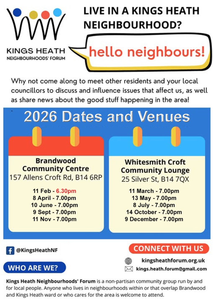
You can also attend any of our upcoming management committee meetings as a guest, see below
We’re pleased to announce we will be hosting local election hustings again in advance of the council elections taking place on Thursday 7th May.
Due to the popularity of our hustings for the previous council elections in 2022, and the size of the ward we’ve decided to hold TWO hustings this time, one in Kings Heath and one in Brandwood. Full details will follow in due course, the dates will be:
Monday 27th April (Kings Heath)
Tuesday 28th April (Brandwood)
The full list of candidates will be announced on 10th April, and we’ll then approach them all with invites. We’re partly announcing the hustings and dates early so that prospective candidates can get as much notice as possible, as well as to help residents plan. If you expect to be a candidate, or you know someone who is planning to stand please pass on the information to them.
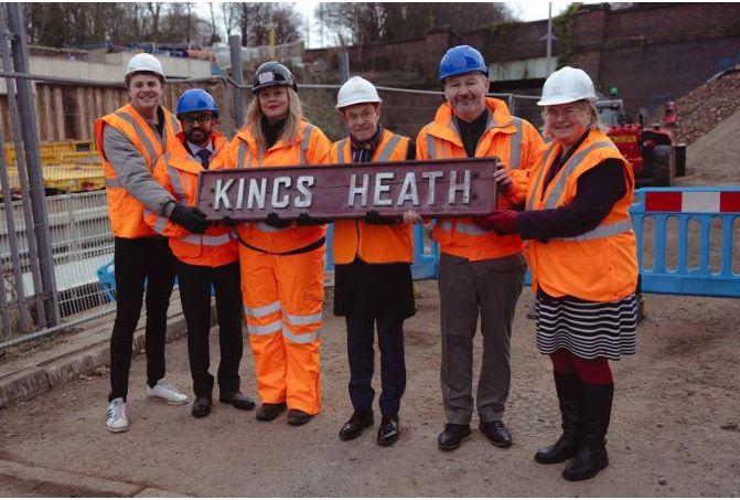
On Wednesday 1st October Kings Heath Neighbourhoods Forum hosted a public meeting with a panel of guests involved with the opening of the Camp Hill Line stations to update residents on progress and answer their questions. The slides from the meeting with extensive details and photos are available by clicking the link. The key information of interest to residents is summarised here, comprising information from the slides, the presentations and the Q&A.
Progress towards opening
The stations will be open for passengers in 2026.
At this stage they cannot confidently forecast or commit to an opening date – see below and the slides for further info on why. From various pieces of information given at the meeting it seems likely this will be no earlier than March ‘26, but before July ‘26.
There will be a lot of publicity once the open date is set, and this will be at least 4-6 weeks in advance of the opening.
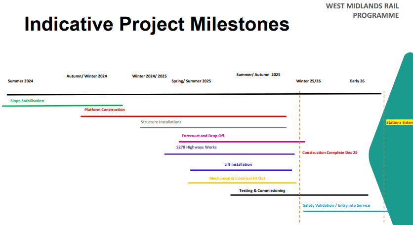
It’s worth noting this does not represent any further delays to the work, as announcements earlier this year referred to the construction of the stations being completed, or the stations being “finished” by the end of ‘25, which is still on track to happen. Before the stations can be used by passengers there is a lengthy and complex process of testing, training, certification and transfer of ownership of the sites to the rail/train operator – called “Entry into service” works. See below project plan from the slides.
Project timeline from presentation slides
Entry into service works are very complex and normally take several months, although some testing can start before the building works are complete (see above) most of this work has to wait until construction is finished. Adding further complication to these sites the ownership of West Midlands Trains is changing in February ‘26, during this period of hand-over/entry into service. The lack of a firm opening date seems to largely stem from the combination of the complexity of the entry into service works leading to uncertainty in how long they will take to complete, along with the current ownership/management of the stations not (yet) being in the hands of the body that will open them.
Official opening
They intend to have a grand opening ceremony and/or party for the stations, but no details are available for this yet.
Highways work is largely completed now, at some point further minor works will be needed to bring the new pedestrian crossing lights into service, and to do some other finishing works including resurfacing one carriageway.
Pineapple Road
Highways work is ongoing and progressing well, expected to be finished in Mid-November
Moseley Village
Some further utilities and highways permissions are being finalised before work can begin fully, this is expected by mid-October, with roadworks to be completed by Mid-December.
Train service details
Trains will run into and out of New Street.
Trains will continue onto Kings Norton (from Pineapple Road) before “turning around”. Passengers will be able to get on or off at Kings Norton.
There will be 2 trains an hour between 06:00-23:00, Monday-Saturday; 1 train an hour on Sunday starting a little later, and finishing a little earlier.
Fares are “zone 3” meaning they will be roughly the same as Kings Norton to New Street, likely a little cheaper. (This is £3.80 peak fare currently).
Trains are 4 carriage, Class 196 diesels. These have a more “open” design than some other more cramped local train types, with increased standing space, and fewer seats. There is nominal storage for 3 bikes per train, but at the discretion of the conductor (as is transport of more than 3 bikes), so it seems likely this will be difficult, if not impossible to guarantee or depend on during peak times.
Station infrastructure
There will be community workshops in the coming months to help inform the details of design and artworks. They intend to have some mosaics as well as some information/history/heritage boards at each site (see examples on the slides). There is a possibility Kings Heath will have a mural, given the strong links with the High Vis Street Art festival and Enjoy Kings Heath (the KH BID).
Kings Heath and Pineapple Road have storage for 32 bicycles, while Moseley has storage for 50.
Parking
None of the stations will have parking, but will have drop-off areas only. There is a station car park at Kings Norton.
Parking on surrounding streets will be monitored. The panel mentioned Birmingham City Council and the WM Mayor office have made assurances they will provide specific support for parking enforcement around the station, in terms of illegal parking.
There has been a previous parking survey conducted to assess the baseline parking levels around the stations prior to them opening, if there are reported issues with a greater volume of parked cars after station opening there will be a second survey conducted around 6 months after opening to compare to the earlier one and assess where these problems are occurring. If problematic increases are shown in the survey comparison then it will trigger a planning and consultation process for making changes to address these issues.
It’s worth noting any concerns and issues which arise can be best addressed at a local level with the local councillors for Moseley, Brandwood & Kings Heath & Stirchley. As well as, from a more long-term perspective, with the respective Neighbourhood Forums for the wards. Neighbourhood Forums are responsible for developing the local ward plans (alongside councillors), and incorporating aspirational measures to tackle problem parking in specific locations can be a useful tool in advocating for future funding allocations. The opening of the stations will roughly coincide with the next local council elections, which also means a subsequent review and update of the various ward plans with the incoming councillors which could be timely.
The future of the line
The station platforms have been built to accommodate up to 6 carriage trains, so there is a possibility of increased capacity there if there is high demand.
The number of trains per hour is constrained by the capacity of New Street and there is very unlikely to be any increase in the number of trains per hour within the next 10 years or so
Opening up further link lines (the “chords”) to take trains into Moor St instead of New Street, and allow more trains per hour is a theoretically possibility but there are no firm plans on table for this at the moment.
It is unlikely the line would be electrified as there is no likelihood of funding to support this.
There are no plans for a process to “name” the line, but this may happen in the future.
The trees cut down near to the line, (mostly between Kings Heath and Pineapple Road) will not be replanted, as these were removed for operational reasons. There may be some replanting with smaller shrubs in places, but sightline and noise issues for residents will be addressed primarily with a 1.8 m high fence.
On 25 November the Kings Heath Neighbourhoods Forum held its Annual General Meeting at the Kings Heath Community Centre. We conducted all the usual business (treasurer’s report, minutes of last meeting, and chair’s report) swiftly and spent most of the evening on a presentation of recent developments in the City and the Ward. The presentation is included below. The evening was concluded with electing local resident James Knight onto the Management Committee.
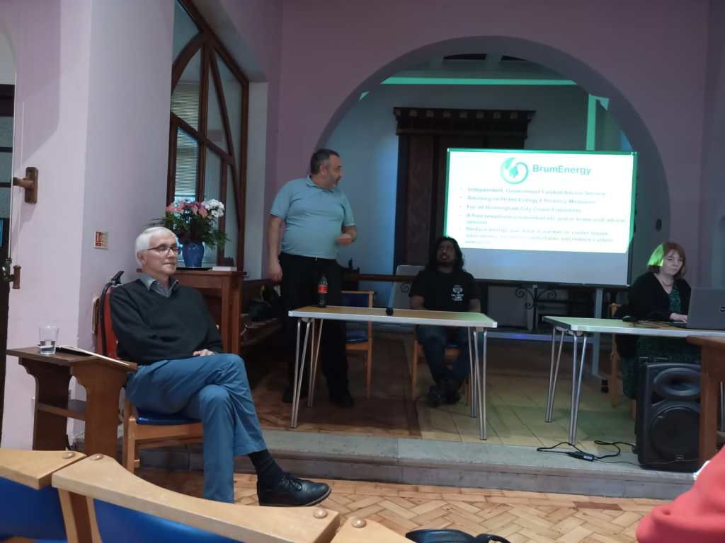
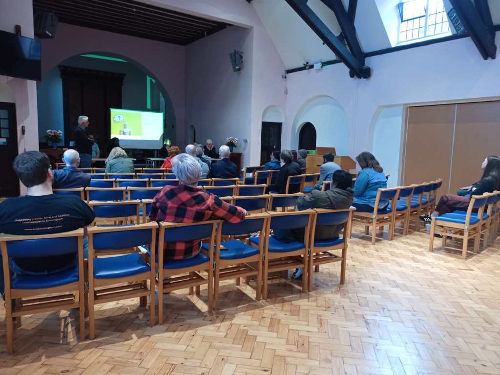
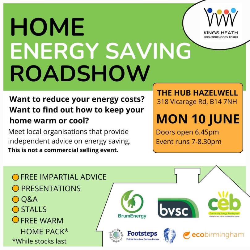
On 10 June the Kings Heath Neighbourhoods Forum organised a Home Energy Saving Roadshow at the Hub Hazelwell. The overarching aim was to point residents towards non-commercial local organisations that can assist with the transition towards cleaner and cheaper home energy systems that also promise an increase in comfort.
The evening had three parts, a presentation by representatives from local organisations, a general Q/A session, and time for individual advice.
The presentations started with Tom Holness giving an overview of BrumEnergy, an umbrella organisation funded by various Government grants delivering free, independent, and high-quality home energy advice to Birmingham residents. 12 local organisations are contributing to this mission (of which three were represented at the event). Their website contains a wealth of advice and pointers to additional resources, but the main takeaway, perhaps, is their offer to provide a free personalised advice session.
Next up was Naomi Standen from ecobirmingham, talking about a range of simple measures that can help bring down energy bills, not just for owner occupiers but also for renters. Taken together, these “easy wins” can result in savings of over £500 annually in a typical household. A good starting point for reading up on this is this page on the BrumEnergy website.
Shaz Rahman from Community Energy Birmingham group spoke about more major interventions and upgrades that will keep your house warm, such as insulating walls. A major take-home message was to carefully plan the sequence of measures, such as improving insulation before changing a boiler for a heat pump.
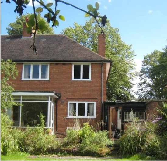
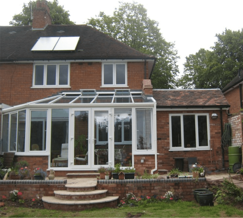
The final presenter was Chris Martin from Footsteps who told us how he converted a neglected Bournville Village Trust property into a highly energy efficient home for himself and his wife. It was nice to see concretely what it means to upgrade a house and to appreciate an outcome that is not only efficient but also aesthetically pleasing:
Some additional points were raised in the general Q/A session, such as the need to consider ventilation in addition to insulation, the main message being to make ventilation something that can be controlled by the occupants according to need, rather than relying on uncontrolled drafts.
In the final part of the evening, people were able to speak to the presenters on an individual basis, getting advice on specific issues that affect their home situation. For this, the participating organisations had set up stalls and brought along additional staff and volunteers, with plenty of freebies on offer to encourage conversations. An additional stand was set up by Joanne Exeter from the Brandwood Center advertising support offered by Cadent (the company that maintains our gas distribution network).
All in all, this was an evening packed with interesting and useful information, inspiring us to take the first steps in our own homes towards a carbon-neutral future.
The Forum have organised a free home energy saving event on Monday 10th June at Hazelwell Hub.
You can find it at 318 Vicarage Road, B14 7NH (Next door to Hazelwell Chruch). Doors open at 6.45pm and event runs from 7.00-8.30pm
This is not a commercial selling event, it is a chance for residents to meet local organisations providing independent advice on home energy saving. There will be stalls, Q&A sessions, presentations, as well as free Warm Home packs while stocks last.